 Official Louisiana State Websites use .la.gov
  Secure .gov websites use HTTPS
 Welcome to our new and improved website! Take a look around, and use the Feedback form to let us know what you think!
Ambient Air Monitoring Program
Current Air Monitoring Data
Data can be viewed in real time. It is displayed based on pollutant type, current concentration, and location across the state and is updated every hour.
More Info
Current Air Monitoring Data
Understanding and managing air quality is essential to protecting public health and maintaining a healthy environment. In Louisiana, this responsibility is carried out through a comprehensive ambient air monitoring program designed to measure pollutants, track long‑term trends and keep communities informed about the air they breathe. The Louisiana Department of Environmental Quality (LDEQ) oversees this effort through its Air Planning and Assessment Division, ensuring that accurate, science‑based information guides environmental decisions across the state.
Monitoring
About Our Operations
Ambient air monitoring operations are the responsibility of the Louisiana Department of Environmental Quality (LDEQ) Air Planning and Assessment Division's Air Field Services Section. Air Field Services (AFS) maintains a statewide monitoring network made up of stationary ambient air monitoring stations. From these sites, analysis personnel collect direct measurements of air pollutant concentrations then analyze and interpret the data. The data collected is used to track trends in air quality and determine compliance with National Ambient Air Quality Standards (NAAQS).
Monitoring sites contain specialized instruments to measure concentrations of the criteria pollutants: ozone, sulfur dioxide, nitrogen dioxide, carbon monoxide, lead, and respirable particulate matter. The AFS also measures concentrations of volatile organic compounds at selected sites throughout Louisiana. Air monitoring staff collect and analyze this data to understand long‑term trends, identify potential problem areas, and determine whether Louisiana meets federal air quality requirements set forth by the Environmental Protection Agency.
The AFS section also reports daily Air Quality Forecasts and readings to the public in the following areas: Baton Rouge, Alexandria, Lafayette, Lake Charles, Monroe, New Orleans, Shreveport, and Thibodaux. DEQ provides this information to radio and television news and local newspapers, who report the air quality reading in a short statement included in the daily weather report, mainly during ozone season. Hourly air quality readings and the daily Air Quality Forecast are also available on this web site. You can subscribe to receive daily emails containing the Air Quality Forecasts and notifications at EnviroFlash. These forecasts are based on the Air Quality Index (AQI), a simple, color‑coded scale that shows whether the air is healthy to breathe.
By providing accurate, real‑time air quality information, the Louisiana Ambient Air Monitoring and Reporting Program helps protect public health, supports environmental planning, and ensures transparency for communities across the state.
Criteria pollutants are six common air pollutants that the EPA (United States Environmental Protection Agency) regulates under the Clean Air Act (CAA) because they can harm human health and the environment. These pollutants include ozone (O₃), particulate matter (PM₂.₅ and PM₁₀), carbon monoxide (CO), sulfur dioxide (SO₂), nitrogen dioxide (NO₂), and lead (Pb). The EPA sets health‑based limits for these pollutants called the National Ambient Air Quality Standards (NAAQS). These six pollutants are found across the United States and can come from cars, industrial facilities, power plants, construction activities, and natural sources like wildfires. Because they are widespread and well‑studied, they serve as indicators of overall air quality.
National Ambient Air Quality Standards
| Pollutant | Primary / Secondary | Averaging Time | Level | Form | Attainment Status |
|---|---|---|---|---|---|
| Carbon Monoxide |
Primary |
8 - hour 1 - hour |
9ppm 35 ppm |
Not to be exceeded more than once per year | Attainment |
| Lead | Primary and Secondary | Rolling 3 month average | 0.15 µg/m3 | Not to be exceeded | Attainment |
|
Nitrogen Dioxide |
Primary Primary and Secondary |
1 - hour Annual |
100 ppb 53 ppb |
98th percentile, averaged over 3 years Annual Mean |
Attainment |
| Ozone |
Primary and Secondary |
8 - hour |
0.070 ppm |
Annual fourth-highest daily maximum 8-hour concentration averaged over 3 years |
Attainment |
|
Particle Pollution PM2.5 |
Primary Secondary
Primary and Secondary |
Annual
24-hour |
9.0 µg/m3 12.0 µg/m3
35.0 µg/m3 |
Annual Mean averaged over three years
98th percentile, averaged over three years |
Attainment |
| Particle Pollution PM10 |
Primary and Secondary |
24 - hour |
150 µg/m3 |
Not to be exceeded more than once per year on average over three years |
Attainment |
|
Sulfur Dioxide |
Primary
Secondary |
1 - hour
3 - hour |
75 ppb
0.5 ppm |
99th percentile of 1-hour daily maximum concentrations averaged over three years
Not to be exceeded more than once per year |
Non-Attainment for St. Bernard Parish only |
Air toxics are pollutants in the air that can cause health problems such as breathing difficulties or long‑term illnesses. In Louisiana, the Louisiana Department of Environmental Quality (LDEQ) monitors these chemicals to help protect community health. Air toxics can come from cars, industrial facilities, power plants, and even natural events like wildfires. LDEQ tracks these pollutants and shares the information with the public so residents can better understand local air quality. This work supports the Air Quality Index (AQI)—a simple, color‑coded scale created by the EPA (United States Environmental Protection Agency) that shows whether the air is healthy to breathe. The AQI helps families, schools, and communities make informed decisions about outdoor activities. Together, air toxics monitoring and the AQI give Louisiana residents clear, accessible information about the air they breathe. For more information, visit the Air Toxics Monitoring Program page.
The Air Quality Index (AQI) is a simple, color‑coded tool created by the EPA (United States Environmental Protection Agency) to show how clean or polluted the air is each day. The AQI helps people understand whether the air is healthy to breathe and whether certain groups—such as children, older adults, or individuals with asthma—may need to limit outdoor activities. The AQI uses six color categories that range from “Good” to “Hazardous,” with higher numbers meaning higher pollution levels and greater health concerns. An AQI value of 50 or below reflects good air quality, while values over 300 represent hazardous conditions. The EPA calculates the AQI using five major pollutants regulated under the Clean Air Act (CAA): ozone (O₃), particle pollution or particulate matter (PM₂.₅ and PM₁₀), carbon monoxide (CO), sulfur dioxide (SO₂), and nitrogen dioxide (NO₂). Because the AQI translates complex air monitoring data into an easy‑to‑understand scale, it allows families, schools, and communities to make informed decisions about outdoor activities. It also supports public health by clearly communicating when air pollution levels may pose short‑term or long‑term risks. The EPA AirNow page has more information about the Air Quality Index.
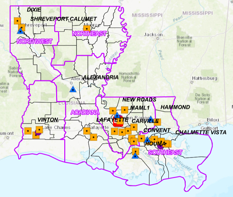
Interactive Map of Ambient Air Monitors
Our interactive Louisiana Ambient Air Monitoring Map gives residents an easy way to explore air quality across the state. The map displays every monitoring site operated by the Louisiana Department of Environmental Quality (LDEQ), showing where air quality data is collected and how conditions vary from one community to another. Each site icon can be selected to view detailed information, including the pollutants measured, the type of equipment used, and the purpose of the monitoring location.
Every monitoring site provides real‑time readings for key pollutants regulated by the EPA (United States Environmental Protection Agency) under the NAAQS (National Ambient Air Quality Standards). These pollutants include ozone (O₃), fine particulate matter (PM₂.₅), coarse particulate matter (PM₁₀), nitrogen dioxide (NO₂), sulfur dioxide (SO₂), carbon monoxide (CO), and lead (Pb). The map also links each reading to the Air Quality Index (AQI)—a simple, color‑coded scale that shows whether the air is healthy to breathe.
By combining location details, pollutant data, and AQI information, the Louisiana Ambient Air Monitoring Map helps residents, schools, and communities stay informed about local air quality. This tool supports transparency, public health, and environmental protection across the state.
Did
You
Know?
Temporary Located Community Ambient Air Monitoring Program
Find out how Louisiana’s TLC Air Monitoring Program supports environmental justice and community health.
Temporary Located Community Ambient Air Monitoring Program
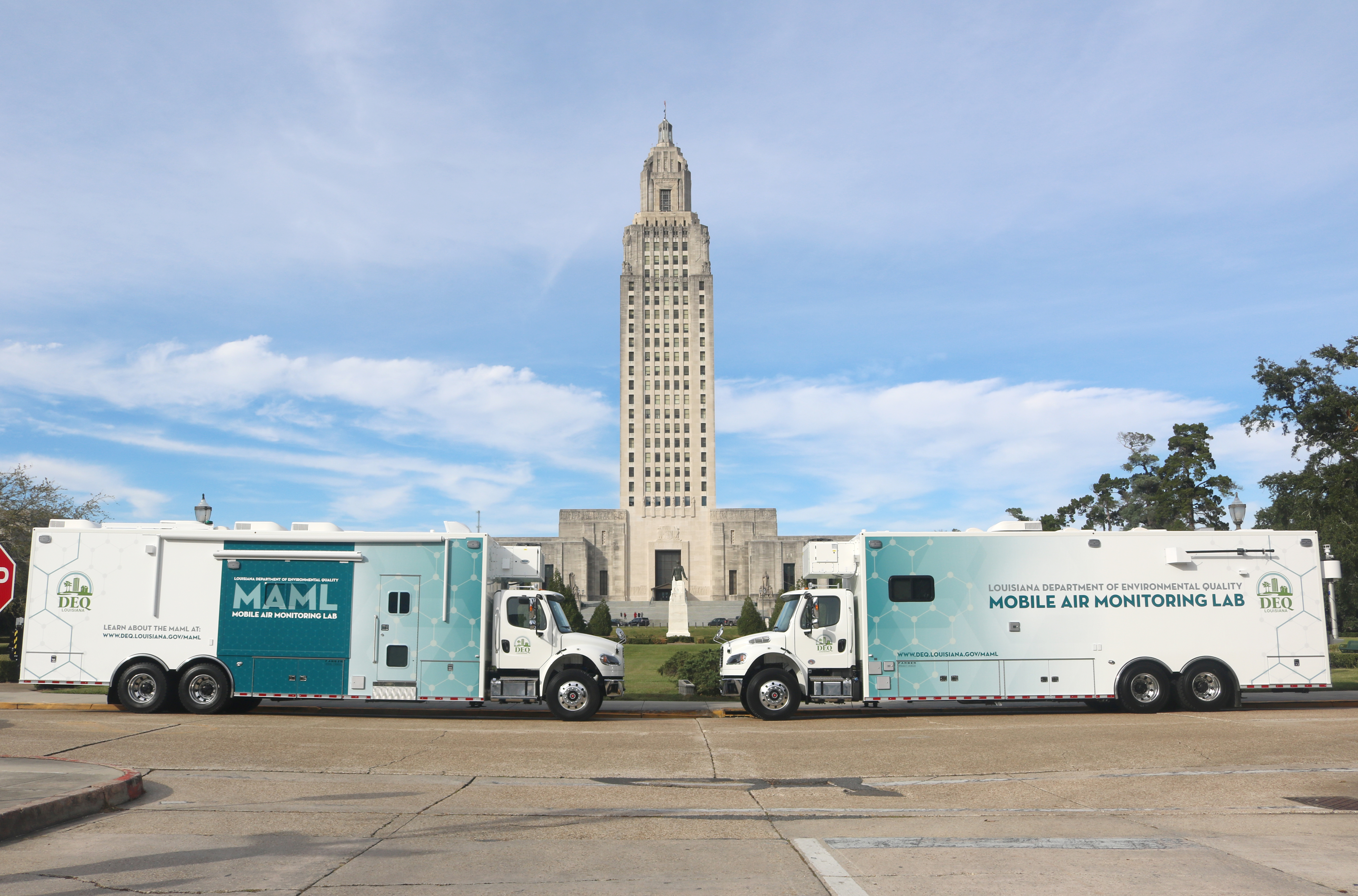
Mobile Air Monitoring Laboratory (MAML)
The Louisiana Department of Environmental Quality has added two new Mobile Air Monitoring Labs (MAMLs) to enhance the Department's ability to monitor the air quality in Louisiana. These state-of-the-art MAMLs were acquired in late 2019 and are outfitted with air monitoring and analysis equipment -- including multiple gas chromatograms. These 40 ft MAMLs allow LDEQ to deploy a full-scale, self-contained air monitoring lab anywhere in the state to gather real time data over short and extended intervals. Proactive monitoring and protection of Louisiana's air is a priority for the MAMLs. This ensures compliance with the National Ambient Air Quality Standards. Other air quality issues that the MAMLs will address are:
- Routine Air Monitoring
- Emergency Response monitoring and support
- Investigating past and present complaints and concerns
- Investigating the cause of air quality exceedances
- Conducting any other air quality issue ordered by the LDEQ Secretary
- Outreach & Community engagement
When the MAML is deployed, data can be accessed at the Current Monitoring Data page.
Reporting
Historical Ambient Air Datasets
Historical ambient air datasets from 2000 to 2023 are accessible through LDEQ. You can view datasets from the past 4 years on the Data Reports page. If you require older datasets, please submit a data request.