 LOUISIANA DEPARTMENT OF ENVIRONMENTAL QUALITY | Secretary Courtney J. Burdette
 A DEPARTMENT OF THE STATE OF LOUISIANA
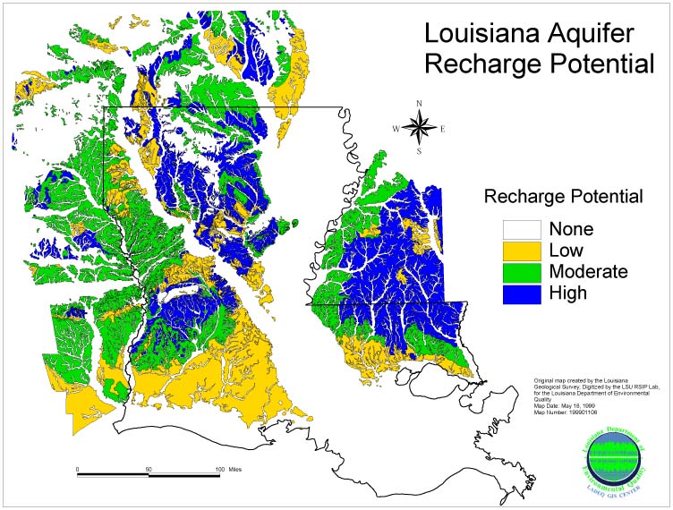
Recharge Potential Maps of Louisiana Aquifers were prepared by the Louisiana Geological Survey in 1989. A statewide map, quadrangle maps (atlas plates), and a supplementary report are available from the Aquifer Evaluation and Protection Unit free of charge upon request. To order the report and any or all of the maps listed below, contact the Aquifer Evaluation & Protection Unit by email at DEQDWPPTeam@LA.GOV or by phone at 225-219-3510 or 225-219-3858. The map set and supplementary report are also available electronically on a flash drive. **Please be sure to include your name and mailing address with your request. Also, specify which map(s) you need and format (paper, electronic, or both).
Available Resources
Map #1 of the Aquifer Recharge Atlas - Texarkana Quadrangle
Map #2 of the Aquifer Recharge Atlas - El Dorado Quadrangle
Map #3 of the Aquifer Recharge Atlas - Greenwood Quadrangle
Map #4 of the Aquifer Recharge Atlas - Tyler Quadrangle
Map #5 of the Aquifer Recharge Atlas - Shreveport Quadrangle
Map #6 of the Aquifer Recharge Atlas - Jackson Quadrangle
Map #7 of the Aquifer Recharge Atlas - Palestine Quadrangle
Map #8 of the Aquifer Recharge Atlas - Alexandria Quadrangle
Map #9 of the Aquifer Recharge Atlas - Natchez Quadrangle
Map #10 of the Aquifer Recharge Atlas - Hattiesburg Quadrangle
Map #11 of the Aquifer Recharge Atlas - Beaumont Quadrangle
Map #12 of the Aquifer Recharge Atlas - Lake Charles Quadrangle
Map #13 of the Aquifer Recharge Atlas - Baton Rouge Quadrangle
Map #14 of the Aquifer Recharge Atlas - Port Arthur Quadrangle
Map #15 of the Aquifer Recharge Atlas - Mobile Quadrangle
Map #16 of the Aquifer Recharge Atlas - New Orleans Quadrangle
 This map shows the aquifer recharge potential across the state of Louisiana only - it does NOT depict the individual aquifers. For that level of detail please order the Recharge Potential Map above.