 LOUISIANA DEPARTMENT OF ENVIRONMENTAL QUALITY | Secretary Courtney J. Burdette
 A DEPARTMENT OF THE STATE OF LOUISIANA
Although nutrients are required to sustain life, too many nutrients in surface waters can lead to less than desirable consequences. Excess nutrients (such as nitrogen or phosphorus) are a nationwide concern in surface waters as they may promote algal growth, result in contamination of drinking waters supply, or even be toxic to aquatic life. Further, excess nutrients draining to surface waters play a role in the development of seasonal low dissolved oxygen levels, potentially causing areas of hypoixa or summer hypoxic zones such as found in the northern Gulf of Mexico.
Hypoxia (or low dissolved oxygen) is when oxygen levels fall below the level necessary to sustain most aquatic life. Waters that have dissolved oxygen concentrations less than 2 parts per million (ppm) for extended periods of time are generally considered hypoxic. Hypoxia can be a problem for estuaries, coastal waters, and some inland waters and can be caused by a variety of factors, including excess nutrients (primarily nitrogen and phosphorus),water body stratification due to salinity or temperature gradients in still waters, and low flows in streams and bayous. These excess nutrients (or eutrophication) can promote algal growth and as the algae die, they sink to the bottom, and decompose; this process of algal growth and decomposition consumes oxygen, resulting in low dissolved oxygen levels in the water.
The direct effects of extended hypoxia include fish kills, which not only deplete valuable fish stocks and damage the ecosystem, but are unpleasant for local residents and can harm local tourism. Oxygenated water is necessary for aquatic animals to breathe. Mobile animals, such as adult fish, can often survive extended times of hypoxia by moving into oxygenated waters. When they cannot move, such as when young fish need to spend time in the habitat that has become hypoxic, the result is a fish kill. Non-mobile animals, such as clams, cannot move into healthier waters and are often killed by hypoxic episodes. This causes a severe reduction of the amount or in extreme cases the complete loss, of animal life in hypoxic zones.
Hypoxia is a complex ecological phenomenon that arises from the convergence of several factors, some of which are altered by human activities. The shape of the water body and the strength and direction of water flow determine how well-mixed (and aerated) the water is. Wind strength and direction and the influence of major storms also affect the rate of mixing and aeration. Human activities, such as changing the amount of freshwater entering an estuary or altering flows of rivers and streams, can reduce the amount of mixing and aeration. Poorly-mixed water increases the chance hypoxia will develop.
Nutrients (primarily nitrogen and phosphorus, but sometimes also including silica, iron, zinc, and magnesium) are necessary for plant growth. An overabundance of these nutrients, combined with enough light and warm, slow-moving, or poorly-mixed water, can result in an algae bloom. This is the first step in the chain of reactions that can lead to hypoxia. These overabundant nutrients may come from point sources such as waste water treatment plant discharges and nonpoint sources such as agricultural activities, urban runoff, groundwater, and atmospheric deposition. The amount of pollutants generated and the rate at which they reach rivers, estuaries and coastal waters are increased by human activities such as the destruction of wetlands, grasslands, and forests in favor of urban, suburban or agricultural landscapes.
Source: World Research Institute
The term "point source" means any discernible, confined and discrete conveyance, including but not limited to any pipe, ditch, channel, tunnel, conduit, well, discrete fissure, container, rolling stock, concentrated animal feeding operation, or vessel or other floating craft, from which pollutants are or may be discharged. This term does not include agricultural storm water discharges and return flows from irrigated agriculture. Nonpoint source (NPS) pollution, unlike pollution from industrial and sewage treatment plants, comes from many diffuse sources. NPS pollution is caused by rainfall or snowmelt moving over and through the ground. As the runoff moves, it picks up and carries away natural and human-made pollutants, finally depositing them into our local watersheds including lakes, rivers, wetlands, coastal waters, and even our underground sources of drinking water. These pollutants include: excess fertilizers, herbicides, and insecticides from agricultural lands and residential areas; oil, grease, and toxic chemicals from urban runoff and energy production; sediment from improperly managed construction sites, crop and forest lands, and eroding stream banks; salt from irrigation practices and acid drainage from abandoned mines; bacteria and nutrients from livestock, pet wastes, and faulty septic systems; atmospheric deposition and hydro modification are also sources of nonpoint source pollution source.
Source: Mississippi River Basin Watershed Nutrient Task Force, 2010
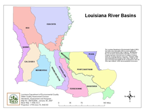
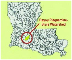
A watershed is an area that drains or contributes water to a particular point, stream, river, lake, or ocean. Larger watersheds are also referred to as basins. Watersheds range in size from a few acres for a small stream to large areas of the country such as the Mississippi River Basin. In Louisiana, water quality monitoring by the Department of Environmental Quality (DEQ) recognizes 12 River Basins, but within those basins, DEQ has delineated over 476 smaller watersheds, called sub-segments, that are also recognized and monitored, as illustrated by the Plaquemine-Brule Watershed.


Sources: Louisiana River Basins Map and Bayou Plaquemine-Brule Watershed Map
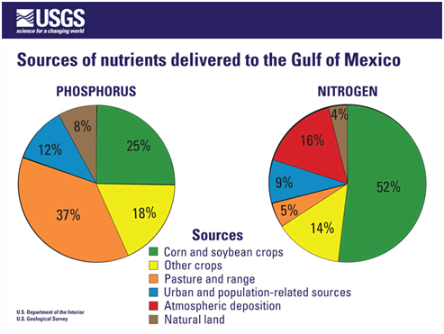
The Mississippi River Basin ultimately drains into the northern Gulf of Mexico, bringing with it increased loads of nutritents. Sixty-six percent (66%) of nitrogen in the basin originates from cultivated crops, mostly corn and soybean, with animal grazing and manure contributing about 5 percent. Atmospheric contributions also are important, accounting for 16 percent of nitrogen.
Animal manure on pasture and rangelands and crop cultivation are the largest contributors of phosphorus in the basin, accounting for 37 and 43 percent, respectively. Findings suggest that phosphorus associated with the wastes of unconfined animals is a much larger source of phosphorus in the Mississippi River Basin than previously recognized. Current animal manure management emphasizes controlling nutrients primarily from confined animal facilities.

In total, agricultural sources contribute more than 70 percent of the nitrogen and phosphorus delivered to the Gulf, versus only 9 to 12% from urban sources. Such findings show the dominance of agricultural nonpoint sources outside urban areas in the Mississippi River Basin.
The Mississippi River Basin carries heavy loads of nutrients to the Gulf of Mexico, routinely resulting in seasonal hypoxic zones. The area of bottom-water hypoxia in the Gulf of Mexico has been monitored and mapped in summer from 1985 to present, except for 1989. A grid of stations was laid out in 1985, transects (lines of stations) were added over the years, and transects expanded to the west as the size of the hypoxic zone increased. The main purpose of the summer monitoring cruise is to map the extent of hypoxia and the physical, chemical and biological parameters associated with it and to link the size with conditions in the Mississippi River watershed. The monitoring and mapping begins at Southwest Pass of the Mississippi River (except in 2010) and progresses westward. Data and field measurements are collected for different depths including depth, temperature, salinity, dissolved oxygen, turbidity, percent photosynthetically available radiation and phytoplankton biomass. Each line of stations is transited so that the stations continue in an offshore or inshore (within the draft of the ship) direction until the area of hypoxia is exited. Some transects are extended past the offshore limits of hypoxia for comparison with prior years. If there is insufficient time to map the entire area, the estimated size may be less than actual size. There has been a consistent mapping protocol over a similar grid since 1985. Instrumentation is calibrated before, during and after the cruise to ensure quality data.
Sources: Gulf Hypoxia and Gulf Hypoxia Mapping
The Louisiana state agencies are developing this Statewide Nutrient Management Strategy in an effort to manage nutrients in inland and coastal water bodies of Louisiana. For more information on the many programs available to help manage nutrients visit the Programs page.